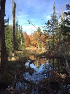
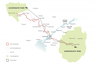
The A2A Collective — formally the Algonquin to Adirondacks Collaborative — represents one of the most consequential examples of an environmental conservation collaborative North America has assembled, linking Algonquin Provincial Park in Ontario to the Adirondack Park in New York across an international border. The corridor spans roughly 1,800 kilometers of temperate forest, wetlands, and transitional habitat, and its success depends directly on the participation of private landowners, rural stewards, and suburban homeowners whose properties sit within or adjacent to the network's path.
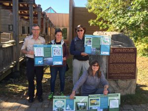
Founded in 2001, the A2A Collaborative operates as a binational partnership, pulling together conservation organizations, Indigenous nations, private landowners, government agencies, and research institutions spread across Ontario, Quebec, and the northeastern United States. The organization holds no land outright; it builds relationships and coordinates action across a mosaic of public and private properties to sustain ecological integrity at landscape scale. For property owners within or near the corridor zone, understanding how the collaborative functions reveals a clear pathway to contributing meaningfully to conservation without surrendering land or relocating.
The underlying science is well-established: biological corridors reduce the genetic isolation that drives local extinctions, allow species to track shifting climate zones, and restore predator-prey dynamics that keep ecosystems self-regulating. Homeowners with even modest lots — a quarter-acre backyard, a rural woodlot, or a naturalized garden border — can extend the corridor's functional reach into areas that maps designate as developed land. Just as stewards have always shaped the landscape through deliberate planting and design, as explored in the long history and evolution of gardens, today's property owners can direct that same intentionality toward corridor connectivity.
Contents
- Debunking Common Myths About Conservation Corridors and the A2A Collaborative
- Proven Strategies That Move the Needle on Habitat Connectivity
- The Monitoring and Mapping Infrastructure Behind the A2A Network
- Long-Term Stewardship: Keeping Habitat Corridors Functional
- Matching Your Contribution Level to the A2A Collaborative's Framework
- A Step-by-Step Guide to Connecting Your Property to the A2A Corridor
- Solving the Most Frequent Barriers to Corridor Participation
- Frequently Asked Questions
- Key Takeaways
Debunking Common Myths About Conservation Corridors and the A2A Collaborative
Misconceptions about corridor conservation are widespread, and they frequently discourage landowners from engaging with programs that would benefit both wildlife and their own properties. Separating fact from assumption is the first step toward productive participation.
Myth: Only Large Landowners Can Make a Difference
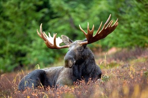
The A2A Collaborative explicitly rejects this premise. The network's model recognizes that small patches of habitat, when contiguous with neighboring properties, create functional stepping stones for wildlife. Research from the collaborative's own monitoring programs documents that species including black bear, moose, and various raptor populations move through connected suburban and agricultural landscapes, not just intact wilderness. A naturalized backyard of 500 square feet contributes measurably to corridor permeability when surrounding properties maintain similar practices.
- Small properties reduce the "gap distance" between larger habitat blocks.
- Contiguous vegetation strips matter more than individual property size.
- Even a single native tree planting adds canopy connectivity in urban fringe areas.
Myth: Conservation Means Doing Nothing to Your Land
Passive neglect is not the same as habitat stewardship. The A2A Collaborative's landowner guidance emphasizes active, informed management — removing invasive species, planting regionally appropriate native vegetation, and managing lawn edges to create structured habitat transitions. Unmanaged land frequently becomes dominated by invasive species such as garlic mustard or common buckthorn, which actively degrade the corridor's ecological function rather than supporting it.
Myth: The Collaborative Imposes Restrictions on Private Property
Participation in the A2A network is entirely voluntary. The collaborative offers technical assistance, planting guides, and connectivity mapping — none of which come with binding land-use obligations. Landowners retain full legal authority over their properties and can withdraw participation at any time without penalty.
Proven Strategies That Move the Needle on Habitat Connectivity
Field experience from the A2A Collaborative's regional coordinators and partner organizations has produced a clear picture of which on-the-ground practices generate the highest connectivity value per unit of effort. The following strategies are ranked by documented effectiveness across the corridor's diverse landscapes.
Pro insight: Native plant species require 60–70% less maintenance than exotic ornamentals once established, making them the highest-return investment for landowners committed to long-term stewardship.
- Vegetated buffer strips: Maintaining a 10–30 meter strip of native shrubs and herbaceous plants along property edges creates immediate permeability for small mammals, pollinators, and ground-nesting birds.
- Reducing outdoor lighting: Artificial light at night disrupts nocturnal movement for dozens of corridor-dependent species; motion-activated, downward-directed fixtures reduce impact significantly.
- Eliminating pesticide use: Broad-spectrum insecticides collapse the invertebrate base that supports amphibians, fish, and insectivorous birds throughout the network.
- Maintaining brush piles and snags: Dead wood structures provide nesting, denning, and overwintering habitat for species that would otherwise bypass developed properties entirely.
- Installing nest boxes: Cavity-nesting species including wood duck, American kestrel, and various owl species use artificial nest structures readily, extending breeding habitat into areas with limited mature timber.
The Monitoring and Mapping Infrastructure Behind the Environmental Conservation Collaborative North America
The A2A Collaborative's operational capacity rests on a robust set of monitoring tools and data-sharing platforms that coordinate action across hundreds of partner organizations and thousands of individual properties. Understanding these resources helps landowners engage more effectively with the network's regional coordinators.
Remote Sensing and Citizen Science Platforms
The collaborative integrates data from multiple monitoring streams to build a continuously updated picture of corridor function:
- Camera trap networks: Deployed by partner organizations at strategic points, camera traps document species presence, movement timing, and behavioral adaptation to human-modified landscapes.
- iNaturalist and eBird: Citizen science observations submitted through these platforms are pulled directly into the collaborative's biodiversity databases, giving coordinators near-real-time species distribution data.
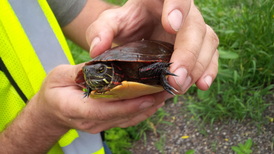
- GPS collar programs: Ongoing telemetry studies tracking wolf, moose, and black bear provide movement corridors data that directly informs priority conservation areas and landowner outreach zones.
- LiDAR-based canopy mapping: High-resolution aerial data identifies gaps in forest canopy cover, allowing the collaborative to target reforestation and native planting initiatives where connectivity is most degraded.
Spatial Planning Resources for Landowners
Partner organizations within the A2A network provide GIS-based mapping tools that show individual landowners exactly where their properties fall within the corridor's connectivity model. These resources allow property owners to make targeted planting and management decisions rather than general habitat improvements without strategic focus.
| Monitoring Tool | Primary Use | Data Access | Landowner Relevance |
|---|---|---|---|
| Camera Traps | Species presence and movement documentation | Partner organizations and researchers | Hosting a camera trap earns direct contribution credit |
| iNaturalist | Biodiversity observation logging | Open public platform | Observations from private land fill critical data gaps |
| eBird | Bird species distribution tracking | Open public platform | Backyard bird counts are scientifically valuable submissions |
| GPS Telemetry | Large mammal movement corridors | Research institutions | Identifies high-priority properties for stewardship outreach |
| LiDAR Canopy Maps | Forest cover gap analysis | Collaborative GIS portal | Shows exactly where tree planting delivers maximum connectivity value |
Long-Term Stewardship: Keeping Habitat Corridors Functional
Corridor habitat is not a set-and-forget investment. Sustained ecological function requires ongoing attention to plant health, invasive species pressure, and structural habitat components that degrade over time without active management.
Native Plantings and Seasonal Maintenance
Native plant communities require deliberate establishment and monitoring, particularly during the first three years before root systems are fully developed. Effective seasonal practices include:
- Spring: Survey for early-emerging invasive species including garlic mustard and phragmites before they set seed; hand-pull or spot-treat immediately.
- Summer: Monitor newly planted natives for drought stress during establishment; supplemental watering during dry periods prevents the mortality gaps that degrade corridor continuity.
- Fall: Leave seed heads and standing stems intact through winter — these provide critical food and cover for overwintering insects and birds.
- Winter: Avoid soil disturbance in naturalized areas; compaction and erosion during the dormant season degrades root systems and invites invasive colonization in spring.
The same planting principles that guide annual seed and transplant establishment in the landscape apply directly to native habitat plantings — soil preparation, spacing, and timing determine long-term success as much as species selection does.
Water Features as Corridor Anchors
Water is the single most effective habitat element a backyard steward can add to the corridor network. Even a modest water feature dramatically increases the number of species that can use a property as a movement node. Amphibians, aquatic invertebrates, waterfowl, and mammals all prioritize water access when navigating fragmented landscapes. Small backyard pond installations — even simple DIY backyard pond designs — create genuine ecological anchors when maintained without chemicals and planted with native aquatic vegetation.
Matching Your Contribution Level to the A2A Collaborative's Framework
The A2A Collaborative explicitly structures participation as a tiered system, recognizing that landowners enter the network with widely varying resources, time commitments, and technical knowledge. The framework prevents the common outcome where high expectations drive away potential contributors before they establish any baseline practices.
Entry-level contributors focus on eliminating practices that actively harm corridor function — pesticide use, exterior lighting, domestic cat access to outdoor spaces, and the removal of native vegetation. These are subtractive changes that require no additional investment and create immediate, measurable benefit.
Intermediate contributors move into active habitat creation: native planting programs, water feature installation, brush pile construction, and participation in citizen science monitoring platforms. At this level, landowners begin generating data that feeds back into the collaborative's regional planning processes.
Advanced contributors engage in formal stewardship agreements with partner organizations, host camera traps or acoustic monitoring equipment, participate in restoration planting events on public lands, and advocate for corridor-friendly municipal policies including dark sky ordinances and wildlife-crossing infrastructure in local planning processes.
A Step-by-Step Guide to Connecting Your Property to the A2A Corridor
Engaging with the A2A Collaborative follows a logical sequence that builds from property assessment through active stewardship and, for motivated landowners, formal partnership. Each step compounds the value of the previous one.
- Determine corridor relevance: Use the A2A Collaborative's online mapping portal to establish whether the property lies within the primary corridor zone, a secondary connectivity zone, or an adjacent influence area. Priority actions differ by zone designation.
- Complete a habitat assessment: Document existing native vegetation, water features, invasive species presence, light sources, and potential wildlife movement barriers such as fencing with inappropriate mesh sizes or no ground clearance.
- Prioritize invasive species removal: Before adding native plants, reduce competition from established invasives. A single season of targeted removal dramatically increases establishment success rates for subsequent plantings.
- Develop a native planting plan: Select species from the collaborative's regionally specific planting guides, which account for local soil types, moisture regimes, and the species assemblages documented by monitoring programs within the relevant corridor segment.
- Install and maintain water features: Even a 150-gallon in-ground basin with native aquatic plantings and a gentle recirculating pump creates functional amphibian and invertebrate habitat within a single season.
- Register with citizen science platforms: Create accounts on iNaturalist and eBird, and begin logging observations from the property. Consistent records from a single location over multiple years produce scientifically meaningful population trend data.
- Connect with a regional coordinator: The A2A Collaborative maintains regional staff who can conduct on-site visits, provide planting materials through partner nursery programs, and flag properties for potential monitoring equipment deployment.
- Formalize participation: For landowners prepared to make long-term commitments, the collaborative offers stewardship recognition programs and can connect interested parties with conservation easement specialists at partner land trusts.
Solving the Most Frequent Barriers to Corridor Participation
Despite the accessibility of the A2A Collaborative's programs, predictable obstacles prevent many willing landowners from translating interest into consistent on-the-ground action. Identifying these barriers in advance allows participants to plan around them rather than abandoning their stewardship commitments when obstacles arise.
Barrier: Budget Constraints on Native Plant Establishment
- Partner organizations within the A2A network frequently offer subsidized or donated native plants through spring and fall distribution events — regional coordinators maintain current program calendars.
- Starting from seed dramatically reduces per-plant costs; many native species including wild bergamot, black-eyed Susan, and common milkweed establish reliably from direct-sown seed in prepared soil.
- Propagating existing native volunteers from elsewhere on the property — common with species including goldenrod, Joe-Pye weed, and native ferns — eliminates cost entirely while maintaining local genetic provenance.
Barrier: Neighbor and Municipal Resistance to Naturalized Landscaping
Municipal bylaws governing lawn height and vegetation density represent the most legally consequential obstacle facing urban and suburban corridor stewards. Many jurisdictions have adopted formal exemptions for certified wildlife habitat gardens; securing certification through programs such as the National Wildlife Federation's Certified Wildlife Habitat designation provides documented justification for naturalized landscape features when complaints arise. Proactive neighbor communication — explaining the ecological purpose of brush piles, unmowed margins, and native plant clusters — reduces friction before it escalates to bylaw complaints.
Barrier: Uncertainty About Which Species to Prioritize
The A2A Collaborative's partner organizations publish regionally specific priority species lists updated on a rolling basis as monitoring data accumulates. Rather than making uninformed selections, landowners within the corridor benefit from requesting a site-specific planting recommendation from their regional coordinator, which accounts for the specific species documented within that corridor segment and the habitat gaps the property can most effectively address.
Barrier: Time Limitations on Ongoing Management
Experienced corridor stewards consistently report that the highest-impact, lowest-maintenance approach involves front-loading effort in the establishment phase — thorough site preparation, dense native planting to suppress invasives through canopy closure, and early intervention on weed pressure in year one — followed by a dramatically reduced maintenance load from year three onward as the native community becomes self-sustaining.
Frequently Asked Questions
What is the A2A Collaborative and what geographic area does it cover?
The A2A Collaborative — Algonquin to Adirondacks — is a binational conservation organization working to establish a connected wildlife corridor between Algonquin Provincial Park in Ontario, Canada, and the Adirondack Park in New York State. The corridor spans approximately 1,800 kilometers and crosses the United States-Canada border, encompassing portions of Ontario, Quebec, and several northeastern U.S. states.
Does participating in the A2A network require signing a legal agreement?
Standard participation in the A2A Collaborative requires no legal agreement. The network is built on voluntary landowner engagement, and participants can modify or discontinue their involvement at any time. Formal conservation easements are a separate, optional mechanism available to landowners who choose to make permanent legal commitments, typically coordinated through partner land trust organizations.
What wildlife species benefit most directly from the A2A corridor?
The corridor is designed to support the full ecological community of eastern North America's temperate forests, but species that benefit most immediately include large mammals with expansive home ranges — black bear, moose, white-tailed deer, eastern wolf, and Canada lynx — as well as wide-ranging raptors, migratory songbirds, and amphibians dependent on wetland connectivity. These species require functional movement pathways across properties and jurisdictions that no single protected area can provide alone.
How does an environmental conservation collaborative North America like A2A differ from a government agency?
The A2A Collaborative is an independent nonprofit organization, not a government agency. It holds no regulatory authority, owns no land, and cannot compel landowner action. Its role is coordination, technical assistance, and partnership-building across a network that includes government agencies, Indigenous governments, conservation organizations, and private landowners — a function that government agencies operating within their own jurisdictional boundaries cannot replicate across an international corridor.
Can urban or suburban property owners meaningfully contribute to the A2A corridor?
Urban and suburban landowners within or adjacent to the corridor zone contribute documented ecological value through native planting programs, pesticide elimination, and citizen science monitoring. The collaborative's connectivity models show that even small urban lots, when adopting corridor-friendly practices, reduce gap distances between larger habitat blocks and enable species movement through otherwise inhospitable developed landscapes.
What native plants are most recommended for properties within the A2A corridor zone?
Recommended native plants vary by region, soil type, and moisture regime, but high-value species consistently prioritized across the corridor include native oaks, serviceberry, wild bergamot, common milkweed, native goldenrods, Joe-Pye weed, and a range of native ferns and sedges for shaded or moist areas. The A2A Collaborative and its partner organizations publish regionally specific planting guides that account for local conditions and documented species needs.
How does removing invasive species help the corridor function?
Invasive plant species reduce the ecological value of corridor habitat by displacing native vegetation that wildlife depend on for food, nesting material, and structural cover. Species including garlic mustard, common buckthorn, and phragmites form dense monocultures that actively exclude native plants and the invertebrate communities associated with them, effectively creating biological dead zones within the corridor that wildlife avoid rather than move through.
Are water features necessary to participate in the A2A network?
Water features are not required for participation, but they represent the single highest-return habitat investment available to most landowners. Even a small in-ground basin with native aquatic plants creates breeding habitat for amphibians, supports aquatic invertebrates, and provides water access for mammals and birds that dramatically increases a property's utility as a corridor movement node. Properties without existing water sources that install even modest features see measurable increases in observed species diversity within one to two seasons.
Key Takeaways
- The A2A Collaborative is a voluntary, binational conservation network linking Algonquin Provincial Park to the Adirondack Park through a 1,800-kilometer corridor that depends on private landowner participation to function across developed landscapes.
- Participation is tiered and accessible — entry-level contributors eliminate harmful practices first, while advanced stewards engage in formal monitoring partnerships and advocacy for corridor-friendly policy.
- Native plant establishment, invasive species removal, and water feature installation represent the three highest-impact actions any property owner within the corridor zone can take to increase habitat connectivity.
- Citizen science contributions through platforms including iNaturalist and eBird feed directly into the collaborative's regional planning data, making backyard observations from individual properties scientifically meaningful at landscape scale.


About Simmy Parker
Simmy Parker holds a Bachelor of Science in Civil Engineering from Sacramento State University and has applied that technical background to outdoor structure design, landscape planning, and backyard improvement projects for over a decade. Her love for the outdoors extends beyond design — she regularly leads nature hikes and has developed working knowledge of native plants, soil conditions, and sustainable landscaping practices across Northern California. At TheBackyardGnome, she covers backyard design guides, landscaping ideas, and eco-friendly outdoor living resources.
You can Get FREE Gifts. Receive Free Backyard Items here. Disable Ad Blocker to get them all now!
Once done, hit anything below